In this guide, you will learn what GIS Mapping and Rest Services are. Then we will dive into how iWorQ's Rest Services work, how to troubleshoot rest services, and we will go over FAQ's.
What is GIS Mapping and Rest Services?
GIS Mapping
GIS stands for Geographical Information Systems. It is a system for visually managing and analyzing data by spatial location.
iWorQ's GIS Mapping connects with all of iWorQ's applications providing agencies with the GIS tools they need to locate and view multiple types of data. Visualizing data on a map increases project efficiency. For example, employees can save time driving back and forth by completing job work orders by location, and since iWorQ functions on any device with an internet connection, Jobs can easily be added or updated on site.
Rest Service
Rest Service (Representational State Transfer) is an architectural style that constrains architectural data to a client/server.
iWorQ's Rest Services make it possible to see and manage up to date information instantly. It integrates with ESRI and connects with a user’s ArcGIS Online account or ArcGIS Server. iWorQ's Rest Service only needs to be set up once. As long as the user maintains their unique ID's, the service will continue to work seamlessly with GIS Mapping.
How it Works
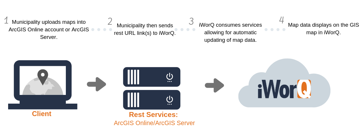
iWorQ's Rest Service only goes in one direction.
Map data is sent directly to iWorQ, not the other way around, Leaving agencies in control of their current data.
1. Municipality uploads maps into ArcGIS Online account or ArcGIS Server
2. Municipality then sends rest URL link(s) to iWorQ.
3. iWorQ consumes services allowing for automatic updating of map data.
4. Map data displays on the GIS map in iWorQ.
Requirements to allow iWorQ to consume rest services:
- You will need an ArcGIS Online Paid account or ArcGIS server.
- A "security certificate" must be set up; this is a small data file that authenticates your website for security purposes. (Your IT department can help get this setup).
- Verify that your data on your server is published and is set to allow access to the public, or if you prefer you can just grant access to iWorQ directly.
- Make sure that the "rest" URL links you send us have HTTPS:// in front.
- You will need to have a Unique ID that is strictly numerical so that your map rest service layers and your data in iWorQ can be linked to each other.
Causes of broken links:
- The unique identifier is not maintained or changed on either the client's end or ours.
- Rest URL's have HTTP instead of HTTPS
- Client Doesn't have a security certificate set up.
- Client not publishing web map services to the public.
- The client is trying to share raster data.
- Having "Record max count" set too low.
FAQ'S
No, rest services are only for the map. It does not update the asset data inside iWorQ.